Dansalan Gardens
| Product Concept |
| Amenities |
| Location |
| Unit and Building Features |
| Site Development Plan |
| Price and Payment Terms |
| Availability |
Who is Integrity Realty?
Dansalan Gardens Project News
| Malaya 093011 |
| Manila Bulletin 092911 |
| Philippine Star 061711 |
| Philippine Star 040811 |
| Manila Bulletin 112210 |
| Philippine Star 111910 |
| Philippine Star 080710 |
Other Information
| Why Choose a REALTOR? |
| FAQs of Buyers |
PROJECTS
| ------- |
| MAKATI |
| ------- |
| MANDALUYONG / SAN JUAN |
| ------- |
| QUEZON CITY |
| ------- |
| TAGUIG / THE FORT |
| ------- |
| PASIG / ORTIGAS |
| ------- |
| MANILA / PASAY |
| ------- |
| PARAÑAQUE / LAS PIÑAS / MUNTINLUPA |
| ------- |
| OUTSIDE METRO MANILA |

INVESTOR UPDATES
| Accolade Place Updates |
| Flair Towers Updates |
| La Verti Residences Updates |
| Siena Park Residences Updates |
| Grass Residences Updates |
| Jazz Residences Updates |
| Light Residences Updates |
PROJECT NEWS
DANSALAN GARDENS - Ready for Occupancy!

DANSALAN GARDENS DMCI Mandaluyong - Location |
|
DANSALAN GARDENS DMCI is strategically located on the corner of Boni Avenue and M. Vicente St., (formerly Dansalan) in Barangay Malamig in Mandaluyong City, Metro Manila, Philippines. It is only three blocks away from EDSA and a few minutes drive to commercial districts of Makati, Rockwell, Ortigas, and Greenhills.
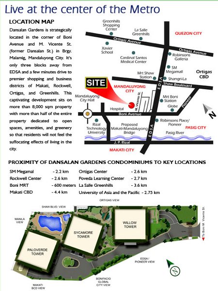 Dansalan Gardens DMCI Mandaluyong Location and Vicinity Map
Dansalan Gardens DMCI is at the quiet side of Mandaluyong City. Here, you are close to important business, commercial and educational establishments. You also enjoy unlimited access to spectacular views of the Makati, Manila and Ortigas skylines. With no other high-rise development nearby to obstruct your view and a well thought-out unit mix and floor layout, each unit here naturally commands a spectacular, almost private glimpse of the city.
 Makati Skyline View from Dansalan Gardens DMCI Mandaluyong
View the embedded image gallery online at:
http://www.integrityrealty.com.ph/mandaluyong/dmci/dansalan-gardens/location.html#sigFreeId0b177b5b66 Vicinity (with a Radius of 3 kms or less)
Transit: MRT-3 Boni Avenue Station (450 m) 1. Schools / Educational Institutions
View the embedded image gallery online at:
http://www.integrityrealty.com.ph/mandaluyong/dmci/dansalan-gardens/location.html#sigFreeId29a4aa45fb Click here to go to Dansalan Gardens DMCI Mandaluyong - Unit and Building Features
|


